Vertical ambition
by Emily Kummerfeld
Young entrepreneur reaches new heights with advanced drone technologies
It’s the unwanted outcome no hunter desires. After hours of patiently waiting, the perfect buck appears in your path. You raise your bow or rifle, aim just behind the front shoulder and fire. But for one of countless reasons, your shot misses the mark. Instead of an instant kill, the animal somehow sprints away and vanishes.
What happens next is hours of searching the dark brush for a blood trail leading to the wounded deer. To leave now would not only be unethical but would also forfeit your trophy. But thanks to technology, you can simplify the hunt and avoid unnecessary pain for you and the buck. Before you descend the stand, you reach into your pocket to make a call.
The man you want is Jack Huston, founder of Midwest Deer Surveys in central Missouri. Using a drone equipped with a thermal camera, he can locate an injured deer—or any other creature with a heat signature—from hundreds of feet in the sky.
 Because time is of the essence when a hunter requires recovery services, he responds promptly. Locating the deer within 48 hours is ideal, with the best chances of recovery occurring within 24 hours.
Huston, a native of Marshall, Mo., understands the challenges hunters face. He grew up hunting with his father and harvested his first deer at age 10. With the advances in unmanned aerial technologies in recent years, he realized the incredible potential of drones as a hunting tool.
Several years ago, Huston received his first drone, a DJI Mavic 3, as a Christmas gift, and from there developed his remote piloting skills. Like many of his generation, he first learned about using thermal drones in hunting from YouTube.
“I was like ‘Wow, that’s amazing technology,’ and saw the opportunity with search and rescue and doing deer surveys,” Huston recalled. “I just jumped right into it.”
He next purchased a DJI Matrice 30T Thermal Quadcopter, which would not only allow him to easily recover injured deer but also survey the wildlife population of a location, invaluable information for property owners.
Seeing the rising potential of thermal technology, Huston started his own business in August 2023, Missouri Drone Deer Recovery, which has since been renamed Midwest Deer Surveys to encompass a larger geographical region.
“I saw such a great opportunity to help landowners manage their properties by knowing how many deer they have and also help people recover deer that they would’ve otherwise not found,” he said.
Elevating an enterprise
In just a few short years, Huston’s business has taken off—literally. He credits the growth to the hard work of securing referrals and social media. “Social media has been a huge part of my business,” he said. “That’s one of my main reasons for collaborating with bigger people in the hunting industry.”
Notable figures include renowned whitetail deer experts such as Don Higgins, Dr. Grant Woods and Bill Winke. Huston carried out deer surveys on their properties, which were showcased in YouTube videos on their channels.
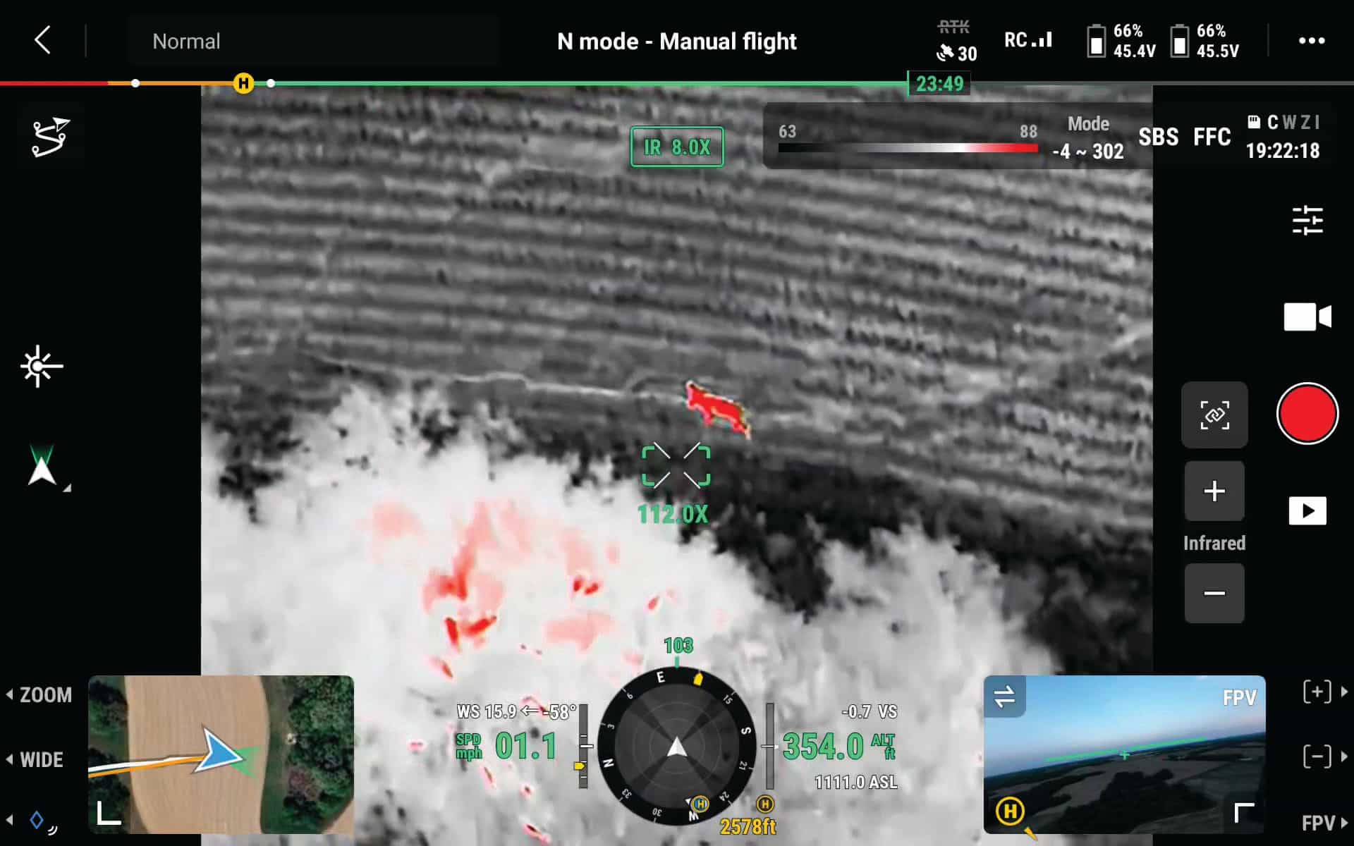
These videos provide a snapshot of what a herd analysis of a property entails, particularly the ability to watch the survey in real time from a large external monitor that enlarges the view of the drone’s controller. Flying high at about 300-400 feet to prevent spooking the deer, Huston uses the thermal camera to look for heat signatures. When he finds one, he switches to the powerful zoom camera for a clear view of the animal. If it’s a deer, he marks the location with a number and a colored pin—blue for does, green for bucks.
After surveys are conducted, clients receive a map of their property with pinned deer locations and videos of any notable findings. Huston also includes a written report with recommendations for land and deer management. For example, the survey will estimate a property’s buck-to-doe ratio and “deer density,” usually given as the number of deer per square mile.
“Ideally, we want to get that buck-to-doe ratio to be one-to-one, depending on the habitat and structure of the property,” Huston explained. “But we try to match the number of deer to the level of habitat to get the healthiest deer herd possible.”
An out-of-balance ratio, usually more does than bucks, can have adverse effects on breeding and resources. Awareness of an imbalance allows a landowner to make better management decisions, such as how many does to harvest the following season to optimize herd health.
“Deer can naturally get a little overpopulated,” Huston said. “I always compare it to a pond. You don’t want your pond to have too many fish.”
Adam Wolfe, owner of Tombstone Tackle in Columbia, Mo., was one of Huston’s first herd analysis clients. After harvesting several does at the end of the season, Wolfe wondered what the current buck-to-doe ratio was on his southern Boone County property. After Huston conducted a survey, Wolfe was amazed that the results showed a higher doe population than he had previously thought.
“This is the biggest game-changer, from a management level,” he said. “You think you can know everything about your farm until you run that drone and find out you don’t know as much as you thought you did.”
Having observed the results of numerous deer surveys on his property and others, Wolfe believes that the state’s actual deer population may be underestimated.
“Now that we have this technology to get an exact count,” he said, “we’re learning the herd is way bigger than we think.”
The sky is no limit
Huston’s knowledge of deer management is impressive, especially since he is currently studying for his master’s degree in accounting through the University of Missouri’s College of Business. He plans to graduate in 2026.
During the fall hunting season, while many classmates are studying for midterms or final exams, Huston is busy working off-campus. “I’d say from Halloween to about Nov. 15, it’s very busy,” he said. “I’ll do almost all my business in those 15 days.”
When both bow and rifle seasons are over, he can focus on his other services, such as deer surveys, which have both a summer season and a busier winter season from November to April, before heavy foliage returns.
“Summer surveys are more of a broad overview, where winter surveys are an in-depth look at your herd when they are most stressed,” Huston explained.
Another service he now offers is detailed aerial property mapping using photogrammetry, which uses overlapping photographs to create 3D images.
“I’ll fly around and take 1,000 to 5,000 pictures of a farm,” he said. “Then there’s some great software that can stitch those together and make a satellite-type image that’s 20 to 30 times better than a satellite 80,000 feet away.”
Additionally, Huston offers search and rescue services for pets and cattle and has even assisted in locating missing people.
While balancing his studies and burgeoning business requires long hours and impeccable organization, Huston is determined to graduate next year and continue growing his clientele. He recently upgraded his equipment by purchasing a Matrice 350 RTK, DJI’s top-tier, professional-grade drone. Not only can it withstand harsh weather conditions, such as wind and rain, but it can also support a heavier payload of several advanced gimbal cameras simultaneously, thereby increasing its survey capabilities.
For example, in addition to the built-in drone camera, Huston attaches a gimbal camera with infrared thermal capabilities, a 34x optical zoom camera, a wide-angle camera, a laser range finder and enhanced night-vision capabilities. He also attaches a spotlight payload for nighttime operations.
The young entrepreneur is well prepared for the upcoming deer season and says he’s ready to test the capabilities of his new equipment.
Navigating an uncertain horizon
It’s no surprise that with such advanced products on the market, DJI—a Chinese company—dominates U.S. drone sales, including the most popular agricultural drone, the DJI Agras T40. But this widespread use in numerous industries—from agriculture and infrastructure to public safety and construction—has also created unease in the U.S. government.
Last December, Congress passed the National Defense Authorization Act (NDAA), which called for a formal security audit of drones made in China. It did not ban Chinese drones outright, but if the audit is not completed by Dec. 23, 2025, DJI drones will be added to the Federal Communications Commission’s “Covered List,” effectively banning their import and sale in the United States.
Although American drone companies exist, users say they tend to fall behind Chinese firms like DJI in terms of technology, performance and price. However, President Trump recently signed an executive order, “Unleashing American Drone Dominance,” which includes several initiatives to accelerate the domestic industry.
While the order will be a helpful step toward ending dependence on foreign drones in the future, it does not eliminate the current uncertainty if the security audit isn’t completed by the December deadline. With a ban in place, existing DJI drones could still be flown and sold second-hand, but there would likely be issues with firmware updates, repairs and insurance coverage.
DJI’s future in the U.S. may be up in the air, but Huston says he’s committed to keeping his business on a positive trajectory.
“My goal is to continue my education and keep working hard on my drone business,” Huston said, resolute in his vision, no matter what lies ahead.
To learn more about Midwest Deer Surveys, visit midwestdeersurveys.com.
Caption to image above: This is a screenshot of the view from the drone’s remote controller. Since the drone can support multiple cameras, the enlarged view shows the attached thermal camera, while the bottom right view displays the drone’s built-in camera. During flight, Huston can easily switch between different cameras. He locates deer with the thermal view, where heat signatures appear as bright red.
Read the article as written via flip book - click here.
Check out more stories in the August/September Today's Farmer Magazine.
Drone Deer Recovery by AIR
Jack Huston founded Midwest Deer Surveys of central Missouri. Using a drone equipped with a thermal camera, he can locate injured deer during dear season—or any other creature with a heat signature—from hundreds of feet in the sky.
Read more from Today's Farmer